Spelle | |
|---|---|
 Flag  Coat of arms | |
Location of Spelle
within Emsland district 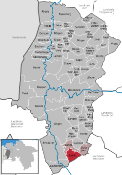 | |
 Location of Spelle | |
 Spelle  Spelle | |
| Coordinates: 52°22′N 07°28′E / 52.367°N 7.467°E | |
| Country | Germany |
| State | Lower Saxony |
| District | Emsland |
| Municipal assoc. | Spelle |
| Government | |
| • Mayor | Andreas Wenninghoff (CDU) |
| Area | |
• Total | 34.2 km2 (13.2 sq mi) |
| Elevation | 35 m (115 ft) |
| Population (2023-12-31)[1] | |
• Total | 10,178 |
| • Density | 298/km2 (771/sq mi) |
| Time zone | UTC+01:00 (CET) |
| • Summer (DST) | UTC+02:00 (CEST) |
| Postal codes | 48480 |
| Dialling codes | 0 59 77 |
| Vehicle registration | EL |
| Website | www |
Spelle is a municipality in the Emsland district, in Lower Saxony, Germany. It is situated approximately 20 km southeast of Lingen, and 10 km north of Rheine.
Spelle is also the seat of the Samtgemeinde ("collective municipality") Spelle.
References
- ↑ "Alle politisch selbständigen Gemeinden mit ausgewählten Merkmalen am 31.12.2023" (in German). Federal Statistical Office of Germany. 28 October 2024. Retrieved 16 November 2024.
| International | |
|---|---|
| National | |
| Geographic | |
This Emsland district location article is a stub. You can help Wikipedia by expanding it. |