You can help expand this article with text translated from the corresponding article in German. (January 2019) Click [show] for important translation instructions.
|
Triptis | |
|---|---|
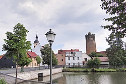
 Town center of Triptis | |
Location of Triptis within Saale-Orla-Kreis district  | |
| Coordinates: 50°44′N 11°51′E / 50.733°N 11.850°E | |
| Country | Germany |
| State | Thuringia |
| District | Saale-Orla-Kreis |
| Municipal assoc. | Triptis |
| Subdivisions | 8 |
| Government | |
| • Mayor (2024–30) | Jan Wißgott[1] |
| Area | |
• Total | 33.15 km2 (12.80 sq mi) |
| Elevation | 358 m (1,175 ft) |
| Population (2024-12-31)[2] | |
• Total | 3,606 |
| • Density | 110/km2 (280/sq mi) |
| Time zone | UTC+01:00 (CET) |
| • Summer (DST) | UTC+02:00 (CEST) |
| Postal codes | 07819 |
| Dialling codes | 036482 |
| Vehicle registration | SOK |
| Website | www.triptis.de |
Triptis (German pronunciation: [ˈtʁɪptɪs] ⓘ) is a town in the Saale-Orla-Kreis district, in Thuringia, Germany. It is situated 22 km southwest of Gera. The town is the seat of the municipal association Triptis.
History
Within the German Empire (1871–1918), Triptis was part of the Grand Duchy of Saxe-Weimar-Eisenach. In East Germany, it was part of Bezirk Gera.
References
- ↑ Gewählte Bürgermeister - aktuelle Landesübersicht, Freistaat Thüringen. Retrieved 25 June 2024.
- ↑ "Bevölkerung der Gemeinden vom Thüringer Landesamt für Statistik" (in German). Thüringer Landesamt für Statistik.
Wikimedia Commons has media related to Triptis.


